| We tend to use combination of GPS (Magellan or Eagle) and
forward looking sonar (Interphase Outlook) for most of our navigation.
We have got Magellan 315 with PC kit (our second GPS). Part of PC kit is
software, which shows track on scanned map. We have got "points of interest"
CD too.
It does excellent job, often in a different way to what I expected.
What we use it for -
-
to see track on its little screen. It gives perfect idea of influence of
drift and tidal stream. I normally set direction on Autohelm 800 and check
on GPS if true direction is what I want. If not, small adjustment on Autohelm
a Alka goes where I want her.
-
315 shows with marker where I'll be in 10 minutes if I continue with the
same speed and bearing. If marker intersects waypoint, or buoy from CD,
I know that it will be a close call even if bow of Alka aims in quite a
different way. It is uncannily accurate.
-
if you go through strange channel you can retract your trip - or section
of it - quite accurately. That is often useful.
-
when I leave strange harbour, I make waypoint mid of entrance. I keep setting
this "home point" as "goto waypoint" and 315 will continuously tell me
the distance. I have returned this way in the dark and my only problem
was to believe what GPS is saying. It is accurate enough.
-
315 also tells me speed over ground, which is often handy and always interesting.
-
when using paper map I set course and continue till lon or lat is what
it should be (e.g. going "down" until I am "level with jetty", then turn
East and keep going until I am close enough to see clearly). Obviously
both values can be used at the same time. You can mark which is "safe strip"
and keep boat inside of it. Easy and requires next to no preparation.
-
315 will tell me overall distance sailed - frankly next to useless, but
VERY interesting. Ends in my log after every trip.
-
315 can provide NMEA signal to other equipment, incl. PC with scanned map.
Problem is, that laptop is a bit costly thing to keep on board and most
laptop screens are almost useless in sunshine, even in the cabin. I have
tried this but did not fall in love with it so far.
-
315 logs track as you go and can download to PC later at home. You can
superimpose it on a scanned map and within a few second you have exact
track of your trip, including all mistakes, course adjustments and hesitations.
It can go to HDD archive as TIF file or on printer.
-
315 has got anchor watch with many options.
-
GPS can check car speedo - it is more accurate and possibly even more legible.
If I set cruise control by GPS I tend to overtake most other cars - most
speedos show more than what you make.
-
315 is mounted in cockpit on 2 velcro dots (second couple of dots is stuck
on the other side of cockpit if I sit on the other side)
All this plus number of other less important things make GPS tool
which I use almost constantly for one or the other purpose.
If I would be looking for new GPS I would require as a minimum graphical
screen and NMEA output to work with PC. Rest is interesting but not essential
to us.
|
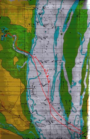
| The picture shows a sample of trip logged by "315" and saved into scanned
chart after return home.
Notes:
-
map is not "registered" perfectly, it is obvious from section in Hastings
channel (and at Tankerton jetty) that red track is slightly shifted.
I should rectify it, but it doesn't matter really - all I need to know
is how much it is shifted.
-
"spikes" in one section are most likely short timed inaccuracies in satellite
reception which logging loop recorded as "important events".
I started from Hastings marina (top left) against sea breeze and tide.
I motored out of channel and continued in generally S direction with intention
to visit Tankerton jetty. After I got level with lat of bottom end of Middle
Spit, I gradually turned E making sure that I'll not be carried N of Tankerton
jetty by tide. For this purpose I continued in direction which aimed S
of Tankerton jetty on GPS screen.
I sailed back; return track being N of outgoing one at first. I just
made sure that screen marker is always left of navigational mark at S tip
of Middle Spit. At later stage I was simply aiming for my waypoint at entry
to Hastings channel.
I "cut corner" at Hastings channel as it was high tide now and I was
able to get over shallows |
 |
![[Razorbill in flight]](gg4-03a-Outlook_and_Magellan.jpg)
